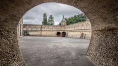
The foundational story of 1066 is a lie built on Victorian vanity and sloppy geography. For over a century, schoolchildren have been taught that King Harold Godwinson made his final stand on the steep ridge of Battle Hill, his shield wall eventually breaking under the relentless pressure of William the Conqueror’s Norman cavalry. It is a cinematic, tidy, and almost certainly incorrect narrative. Modern topographical analysis and a glaring absence of archaeological evidence suggest the most famous clash in English history did not happen where the English Heritage signs say it did.
By placing the battle at the site of Battle Abbey, Victorian historians prioritized romantic symbolism over military reality. They fell for a medieval marketing campaign started by the monks of the 11th century who wanted to cement their monastery’s prestige. This wasn't just a minor oversight. It was a wholesale distortion of the terrain that dictated the fall of Anglo-Saxon England. When you strip away the Gothic sentimentality, you find a battlefield that makes no tactical sense for a commander of Harold’s experience. Building on this topic, you can find more in: Why the Green Party Victory in Manchester is a Disaster for Keir Starmer.
The Ghost of an Army
If 10,000 men died on a single hillside in a single day, the ground should be a graveyard of iron and bone. Yet, decades of professional excavations at the traditional site in Battle, East Sussex, have yielded nothing. No arrowheads. No broken sword pommels. No mass graves. While acidic soil can dissolve bone over centuries, it does not swallow iron.
The traditional site lacks the "blood and iron" signature found at every other major medieval conflict zone, from Towton to Bosworth. This silence from the earth is the loudest piece of evidence we have. It suggests that while the Abbey stands as a monument to the victory, it does not mark the actual geography of the slaughter. The Victorians ignored this void because they were obsessed with the idea of a "Great Man" history, where a king falls exactly where a high altar was later built. Observers at USA Today have shared their thoughts on this situation.
Caldbec Hill and the Tactical Reality
A veteran general like Harold Godwinson would never have chosen the traditional site for a defensive stand. It was too small, too constricted, and offered no viable line of retreat. The real fight likely occurred a mile to the north, at Caldbec Hill.
Caldbec Hill sits at the junction of the main tracks leading to London. It is the highest point in the area, offering a commanding view of the surrounding ridges. More importantly, it features the "Malfosse," a notorious steep-sided ravine mentioned in early accounts as the place where many Normans tumbled to their deaths during a chaotic pursuit. There is no such feature at the traditional Abbey site. By forcing the narrative onto the Abbey grounds, historians erased the very terrain features that defined the battle’s brutal climax.
Harold was a master of the shield wall. This formation required a specific frontage to be effective—roughly 600 to 800 meters of level ground. The ridge at the Abbey is cramped and irregular. At Caldbec, the plateau is broad enough to support the full strength of the Housecarls and the Fyrd. The Normans didn't just walk up a hill; they struggled against a position that was strategically sound until the very moment the English line broke.
The Monastic PR Machine
The confusion began with the Benedictine monks. After the conquest, William the Conqueror allegedly ordered the construction of an abbey to atone for the bloodshed. The monks claimed the high altar sat exactly where Harold fell.
This was a lucrative claim. It turned the Abbey into a site of pilgrimage and political power. In the medieval world, location was everything. If the monks could prove their church sat on the "spot of blood," they secured royal patronage for centuries. The Victorians, with their penchant for blending national myth with physical monuments, accepted the monks' 900-year-old press release as objective fact. They didn't question the logistics; they celebrated the monument.
Reevaluating the Norman Strategy
William the Conqueror was not a gambler. He was a cold, calculating logistical genius who understood that his window of opportunity was closing. He had been stuck on the coast for weeks, his supplies dwindling, his horses weakening. He needed a decisive engagement, and he needed it before the English reinforcements could arrive from the north.
If the battle happened at Caldbec Hill, the Norman approach becomes much more impressive. It shows a forced march through difficult terrain to catch Harold before he could fully fortify the "Hoar Apple Tree," the traditional meeting point for the English army. This wasn't a static fight on a single hill. It was a fluid, desperate struggle across the Sussex Weald. The Norman victory wasn't just about a lucky arrow to the eye; it was about superior mobility and the ability to exploit a gap in the English line on a much larger scale than the traditional site allows.
The Cost of Historical Inertia
Why does this matter now? Because when we misplace a battlefield, we misunderstand the nature of the society that fought there. By clinging to the Victorian site, we ignore the sophistication of Anglo-Saxon military engineering and the true brutality of the Norman scorched-earth policy.
The academic establishment is often slow to move. Admitting that the centerpiece of the 1066 narrative is in the wrong place requires rewriting textbooks, changing tourist signage, and acknowledging that a billion-pound heritage industry is built on a mistake. But the evidence from LiDAR scanning and soil analysis is becoming impossible to ignore. The ridge at Battle is a commemorative park, not a war zone.
The Malfosse Mystery
The most damning piece of evidence remains the Malfosse. Early chroniclers describe a "great ditch" or hidden rampart where the Normans suffered their heaviest casualties during the final stages of the fight. Despite exhaustive searches, no such feature exists near the Abbey.
However, near Caldbec Hill, the terrain drops away into a series of treacherous gullies that perfectly match the descriptions found in the Gesta Guillelmi. These ravines are the missing link. They represent the moment where the English almost turned the tide, catching the Norman cavalry in a natural trap. To find the bodies of the fallen, archaeologists shouldn't be digging under the manicured lawns of the Abbey; they should be looking in the silted-up depths of the Malfosse.
How to Recalibrate the Narrative
To find the truth, we have to look past the stone walls and the statues. The real Battle of Hastings was likely a sprawling, three-mile engagement that began on the slopes of Caldbec and ended in the slaughter at the Malfosse.
- Follow the water: Medieval battles always avoided marshy bottoms, yet the traditional site is surrounded by ground that would have been a bog in October 1066.
- Analyze the frontage: Measure the actual space needed for 7,000 men to stand shoulder-to-shoulder. The Abbey ridge simply cannot accommodate them.
- Trust the metal: Until a significant cache of 11th-century weaponry is found, every theory about the Abbey site remains a guess.
The ground does not lie, but people do. Sometimes they lie for God, sometimes for King, and sometimes just because they didn't want to walk another mile into the woods to find the real site. We are currently standing in the shadow of a Victorian fantasy, looking at a landscape that has been curated to tell a story of neat, orderly conquest. The reality was much messier, much larger, and located on a different hill entirely.
Go to Caldbec Hill. Look south toward the sea and imagine the Norman banners cresting the ridge. That is where England was lost.
Check the local topography maps for the Sussex Weald and compare the elevations of Caldbec Hill against the current Abbey site.